
Who we are
At Frontier Drone Works, we believe the future of surveying, mapping, and site intelligence lives above the ground.
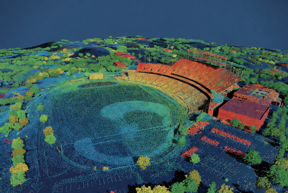
We specialize in drone-enabled geospatial services that help clients better understand the land they build on, manage, and maintain. From construction progress tracking and volumetric surveys to golf course turf analysis and aerial inspections, our mission is to deliver clear, actionable data through modern aerial technology.
Our faith in Jesus Christ shapes the way we do business. We believe that our work is ultimately an opportunity to serve others with excellence, integrity, and humility. Every project is approached with a commitment to honor God through honest communication, quality craftsmanship, and genuine care for our clients.Meet The Founder

Chike Otaluka
Hi, I’m Chike — founder of Frontier Drone Works.
I’m a U.S. Naval Officer, photographer, and technology enthusiast with a passion for aviation, mapping, golf, and the outdoors. I’ve always been drawn to the intersection of land, data, and visual storytelling — finding better ways to understand the world around us through technology and perspective. Frontier Drone Works was built from that passion.
What started as an interest in drones and aerial photography quickly evolved into a deeper appreciation for mapping, surveying, and geospatial services. I became fascinated by how aerial data could help people make smarter decisions — whether that’s tracking construction progress, managing turf conditions on a golf course, inspecting property, or visualizing land from an entirely new angle.
Beyond the technology itself, I care deeply about serving people and building meaningful relationships within the community. As a follower of Jesus Christ, I believe business is an opportunity to serve others with integrity, excellence, and humility while honoring God through my work.
When I’m not flying or working on projects, you’ll usually find me on a golf course, behind a camera, watching sports, or spending time outdoors with my family. Frontier Drone Works is a reflection of those passions — combining precision, creativity, and a genuine appreciation for the land below.
Why Choose Us
At Frontier Drone Works, we believe aerial technology should provide more than impressive visuals — it should deliver clarity, efficiency, and actionable insight. We combine modern drone technology with precision mapping and a passion for the land below to help clients make smarter decisions with confidence.
Whether it’s documenting construction progress, analyzing golf course conditions, or capturing large-scale aerial data, we approach every project with professionalism, attention to detail, and a commitment to quality.
- FAA Part 107 Certified
Operated safely and legally with a commitment to industry standards and responsible flight operations - Construction & Progress Monitoring
Track site development, document milestones, and improve project visibility from above. - Golf Course & Turf Analysis
Aerial perspectives that help better understand course conditions, layout, and turf management needs. - Drone-Enabled Geospatial Services
Modern aerial mapping, surveying, and visualization solutions tailored to your project. - Precision & Reliability
Accurate data collection and dependable results you can trust.